
UTC
What changed on the ground, on the record.
Aerolant reads satellite, aerial, and other visual data covering critical assets, and converts every verified finding into a dated, georeferenced record that holds up under audit.
The problem
The interval between instrumentation and inspection.
Every critical asset is observed in two ways today. Instrumentation delivers continuous data at the points where it is installed. Field inspection delivers observation wherever it reaches, whenever it passes. Both are necessary, and neither covers the interval that remains between them.
Within that interval the asset keeps changing. A new access road toward the easement, a slope movement, a watercourse advancing toward the installation, third party activity: usually visible for weeks before an event, in a place where nobody happened to be looking that day. The condition that precedes a failure rarely appears suddenly. The difficulty is not the absence of signal but the absence of an observation that records it.
When the event occurs, the questions are not about the day of the incident but about the weeks before it: what conditions existed, since when they were visible, and what was done about them. The organization that recorded that period answers with dated evidence. The one that did not reconstructs it afterwards, from spaced overflights and the memory of field personnel.
Capabilities
Provider independent
Aerolant is independent of every imagery provider, satellite or aerial. Each asset is observed with the source its terrain and its threat require, and the selection responds to what the asset needs rather than to any provider's inventory.
Analyst verified
Every detection is reviewed and validated by an analyst before it reaches the client, so the receiving team works on verified events rather than automatic alerts it must filter itself. That analyst assigns severity under the operational criterion agreed with the client.
Method
How a finding becomes a record
Design
The work begins with a coordinate and a technical conversation: which threats the asset concentrates, how it is observed today, and what your team would do with validated detections. Those answers define the sources, the cadence for each zone, and the criterion by which severity is assigned.
Baseline and comparison
Once the baseline is established, each new observation is compared against the previous ones, and the physical changes that appear between them are flagged.
Analyst review
Every detected change passes through analyst review, where it is validated, classified under the agreed criterion, and incorporated into the report. Nothing reaches a client unverified.
The record
You receive georeferenced events with coordinates, date, type of change and image evidence, together with the context needed to decide whether a field verification is warranted. Findings, annotated imagery and reports live in one console, and each delivery adds to the asset's history.
The console
Where the record lives
Findings, annotated imagery, and reports live in one console built around the client's operation. What follows is the console itself, on a real site.
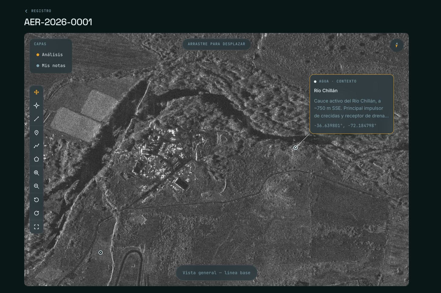
AEROLANT CONSOLE · DEMO DATA
What is detected
Physical change on the asset and its area of influence.
Comparison between successive observations identifies physical change, regardless of the sector the installation belongs to.
- New roads and access routes
- Earthworks and excavations
- Changes to the installation's perimeter and surface
- Recurrent presence of machinery and vehicles
- The advance of erosion and watercourses toward the installation
- Third party occupation and intervention within the area of influence
- The presence and duration of vessels at berths and anchorage areas
- Visible anomalies on the water surface within the operating area
The record
What a record contains
Every measurement is recorded with date, coordinates and image evidence. Over time each asset accumulates a continuous physical history, available for integrity assessments, audits, expert proceedings, regulatory requests and expansion planning.
Every Aerolant record carries the same structure, without exception:
- Capture date, time, and pass
- Source and sensor type
- Georeferenced location, tied to the client's own asset naming
- The current frame and the reference frame it was compared against
- Finding classification and description
- The reviewing analyst's name and sign-off timestamp
A record with a gap in that structure does not ship.
The record as an asset.
What is monitored today becomes the reference tomorrow. The baseline of an asset only exists after measuring it over time: it cannot be bought, imported or reconstructed backwards; it accumulates. After three years, the history an operation has accumulated cannot be replicated, and it constitutes an asset in its own right.
When an event occurs, the questions are not about the day of the incident but about the weeks before it, and that period has to be on record before the event happens. An independent, dated, georeferenced history allows the integrity assessment and the response to the regulator to rest on record rather than on reconstruction.
Observation sources
Each source answers a different question.
The appropriate combination is defined by terrain, by dominant threat, and by the observation window available.
- Optical
- A direct, high resolution reading of the ground: new roads and access routes, machinery, construction, third party occupation, land use change. The reference source for territorial control, easement and corridor surveillance, and fixed infrastructure.
- SAR
- Synthetic aperture radar measures the ground with its own signal, at night and through cloud, which guarantees observation on defined dates regardless of weather. The reference source in jungle, highland and persistently cloudy zones, and at marine terminals.
- InSAR
- Radar interferometry compares the phase of successive acquisitions over the same scene and measures ground displacement. The reference source for geotechnics and mining: slope deformation, settlement, and movement on the crests of deposits and structures. Processing is performed in house.
- Multispectral
- Bands outside the visible spectrum characterize the condition of vegetation cover, soil and water. The reference source for environmental and forestry monitoring: vegetation loss and stress, burn scars, the advance of agricultural fronts.
- Aerial
- Aircraft and drone acquisitions, and imagery the client already holds, where a satellite pass cannot give the resolution or the timing a site needs. They enter the same comparison and the same record as every other source.
No source is superior to the others. There is a correct combination for each asset, and that selection is part of the service.
Sectors
One capability, wherever ground truth matters
- Pipelines and rights of way
- Third party presence changes week to week, and the environment evolves on its own. Monitoring covers the full corridor at the cadence each zone requires, and operates precisely where instrumentation does not reach.
- Marine terminals and storage
- What an operator later needs to demonstrate is rarely an isolated image but a sequence: which vessel was present, when it arrived, and how long it remained.
- Mining
- The dominant question is geotechnical: how slopes, benches and the crests of tailings facilities behave over time. Radar interferometry observes deformation and settlement.
- Transmission and energy
- A transmission line faces the same third party and environmental threats as any linear asset: corridor occupation, unauthorized construction, vegetation encroachment and erosion along the route.
- Rail
- Two categories of threat are rarely observed often enough: third party intervention on the track and its corridor, and the geodynamics of the surroundings on hillside sections and watercourse crossings.
- Agroindustry and large properties
- The surface exceeds the capacity to patrol it, and the relevant changes occur where nobody is looking: third party occupation, land use change along boundaries and the advance of agricultural fronts.
- Environmental and forestry
- Multispectral monitoring characterizes cover condition and delivers the dated sequence of an area before and after an event, so damage can be dimensioned and recovery prioritized.
- Wildfire
- The record documents burned extent, vegetation cover condition, and new access routes toward the area, with a dated before-and-after sequence that lets damage be sized and recovery prioritized. Imagery arrives on a schedule: the value is in the zone's history, not in tracking a fire while it burns.
- Government and territory
- The surface under a public entity's responsibility exceeds the capacity to patrol it. Monitoring documents unauthorized roads and airstrips, earthworks, new construction and occupations, and cover condition in protected areas.
The sources and the record are the same; only the assets change.
Scope
What the service covers, and what it does not.
Imagery arrives on a schedule, so Aerolant documents ground conditions over time rather than alarming in real time. Sensors read terrain, structures, and surface change; they do not see through roofs, into enclosed structures, or detect gas. Detection models assist the analysis, and an analyst verifies every finding before it reaches a client.
Contact
Everything begins with a coordinate.
The first step is a technical conversation about a specific asset: how it is observed today, which threats it concentrates, and what your team would do with validated detections over that zone. With those answers, a first scope is defined.
Already a client? Log in